


このアプリのYoutube動画がある場合はURLを送信してください。詳細 »
APPLICATION INFO - iPhoneアプリの詳細情報
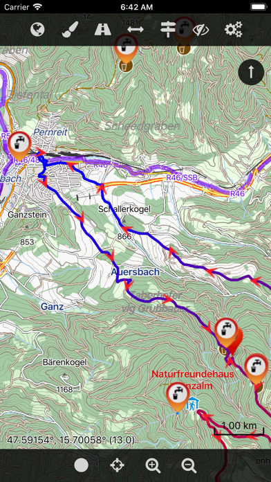
The Cartograph Lite app views Mapsforge offline vector maps, offline raster maps, and online/WMS maps. It supports tracking, route search, overlays, hillshading, reliefs, track drawing, and has many other features.
Pro-version: https://itunes.apple.com/us/app/cartograph-2-maps/id1082995961?ls=1&mt=8
### Lite Version Features ###
- View Mapsforge offline vector maps.
- Offline raster maps: Locus SQLite maps, MBTiles, TwoWays/CompeGPS RMAP*, Oruxmaps SQLite*.
- Online map support (including WMS - Web Map Service maps), e.g. OpenStreetMap, OpenCycleMap, OpenSeaMap, WikiMedia hillshading.
- GPX import and export (basic KML import support).
- Scalable interface (e.g. to increase button sizes).
- Units: Celsius, Kelvin, Fahrenheit, metric, imperial, nautic.
- WaterSupply.at drinking water sources.
- Worldwide, free offline maps.
- Contour lines (Mapsforge maps).
### Additional Pro Features ###
- GPS Track recording.
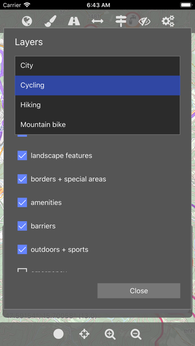
- Full support for Mapsforge styling/render themes (including hillshading) and layers.
- Custom online map sources.
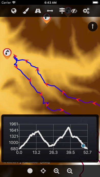
- Offline hillshading (from HGT/SRTM elevation data).
- Offline relief shading.
- Offline slope map.
- Support for Mapsforge multi-maps (multiple .map files stitched into a single map).
- Night/day mode.
- Manual track drawing and editing.
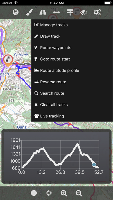
- Route altitude profile and elevation/slope visualization.
- Online route search.
- Live tracking and polling (using custom server, GPSies.com, or Cartograph server).
- Support for Mapsforge POIs, offline POI search, and dynamic POI loading.
- Compass.
- Decimal and degree coordinate modes.
- Customizable user interface color (dark, light, and colors) and size.
- Strava upload.
* RMAP and Oruxmaps use various map projections and support is experimental. Please contact us if a map does not work so that we can add support for your projection.
Further information: http://www.cartograph.eu
Getting started: https://www.cartograph.eu/gettingstarted
Help&Tutorial: https://www.cartograph.eu/docs
User manual: http://www.cartograph.eu/downloads/usermanual_en.pdf
YouTube how-to videos: https://www.youtube.com/watch?v=dn9EOg5h3yY&list=PLP8X6xYv-qCz46hplsfGLW1LNgywBZrTk
Full version: https://itunes.apple.com/us/app/cartograph-2-maps/id1082995961?ls=1&mt=8
Drop us a line if you have questions, feature requests, or other comments: http://www.cartograph.eu/contact
### Maps ###
- OpenAndroMaps.org: very good maps for outdoor activities.
Pro-version: https://itunes.apple.com/us/app/cartograph-2-maps/id1082995961?ls=1&mt=8
### Lite Version Features ###
- View Mapsforge offline vector maps.
- Offline raster maps: Locus SQLite maps, MBTiles, TwoWays/CompeGPS RMAP*, Oruxmaps SQLite*.
- Online map support (including WMS - Web Map Service maps), e.g. OpenStreetMap, OpenCycleMap, OpenSeaMap, WikiMedia hillshading.
- GPX import and export (basic KML import support).
- Scalable interface (e.g. to increase button sizes).
- Units: Celsius, Kelvin, Fahrenheit, metric, imperial, nautic.
- WaterSupply.at drinking water sources.
- Worldwide, free offline maps.
- Contour lines (Mapsforge maps).
### Additional Pro Features ###
- GPS Track recording.
- Full support for Mapsforge styling/render themes (including hillshading) and layers.
- Custom online map sources.
- Offline hillshading (from HGT/SRTM elevation data).
- Offline relief shading.
- Offline slope map.
- Support for Mapsforge multi-maps (multiple .map files stitched into a single map).
- Night/day mode.
- Manual track drawing and editing.
- Route altitude profile and elevation/slope visualization.
- Online route search.
- Live tracking and polling (using custom server, GPSies.com, or Cartograph server).
- Support for Mapsforge POIs, offline POI search, and dynamic POI loading.
- Compass.
- Decimal and degree coordinate modes.
- Customizable user interface color (dark, light, and colors) and size.
- Strava upload.
* RMAP and Oruxmaps use various map projections and support is experimental. Please contact us if a map does not work so that we can add support for your projection.
Further information: http://www.cartograph.eu
Getting started: https://www.cartograph.eu/gettingstarted
Help&Tutorial: https://www.cartograph.eu/docs
User manual: http://www.cartograph.eu/downloads/usermanual_en.pdf
YouTube how-to videos: https://www.youtube.com/watch?v=dn9EOg5h3yY&list=PLP8X6xYv-qCz46hplsfGLW1LNgywBZrTk
Full version: https://itunes.apple.com/us/app/cartograph-2-maps/id1082995961?ls=1&mt=8
Drop us a line if you have questions, feature requests, or other comments: http://www.cartograph.eu/contact
### Maps ###
- OpenAndroMaps.org: very good maps for outdoor activities.
 このアプリはiPhone、iPadの両方に対応しています。
カテゴリー
ナビゲーション
ナビゲーション
リリース
2018/6/18
2018/6/18
更新
2020/1/2
2020/1/2
バージョン
2.6.0
2.6.0
言語
サイズ
49.6 MB
49.6 MB
条件
このバージョンの新機能
Bug fixes.
Bug fixes.
スクリーンショット - iPhone | iPad
スクリーンショット - iPhone | iPad
Harald Meyer の他のアプリ » もっと見る
» 目的別iPhoneアプリ検索
- 辞書 » 日本語対応の辞書 » 英和辞典
- 学習 » 英単語 » 英会話 » クイズで楽しく
- スケジュール » 管理 » Googleカレンダー


CatchApp新着アプリレビュー
 日本縦断てつどうの旅」")
様々な楽しみ方で運転士として成長していく鉄道運転士育成RPG「プラチナ・トレイン(プラトレ) 日本縦断てつどうの旅」
2016-05-17 00:00

日本語にはない英語発音のリスニングを楽しく学べる「発音どっち?英語リスニング 」
2014-12-20 12:00

指先の瞬発力が試されるカジュアルゲーム「早撃ちパニック」をリリース!
2014-12-08 15:21
新着アプリ動画
-
 ¥1500
¥1500

-
 ¥600
¥600
-
 ¥3000
¥3000