


このアプリのYoutube動画がある場合はURLを送信してください。詳細 »
APPLICATION INFO - iPhoneアプリの詳細情報
"Head and shoulders above the crowd is The Photographer’s Ephemeris. Odd name, great app." - National Geographic
"One of the most useful apps for any nature photographer" - Outdoor Photographer Magazine
"It worked perfectly. The program was dead on…" - National Geographic
"One of the most powerful photography applications that I've seen, one that you'll be using for years and years." - AdoramaTV
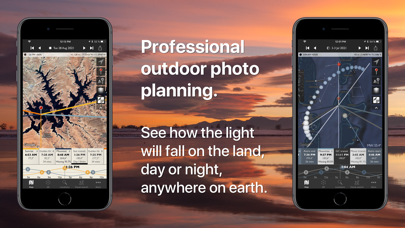
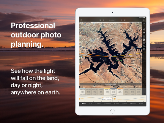
The Photographer's Ephemeris (TPE) helps plan outdoor photography shoots in natural light, particularly landscape and urban scenes. It's a map-centric Sun, Moon and Milky Way calculator: see how the light will fall on the land, day or night, for any location on earth.
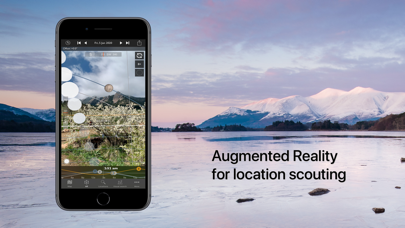
Whether you need at-a-glance information on today's sun, moon and Milky Way data for your current location, or need to plan a precise alignment of the full moon for a future shoot, TPE has the tools you need. The combination of augmented reality, line-of-sight analysis and visual search supports the most sophisticated photo planning needs.
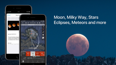
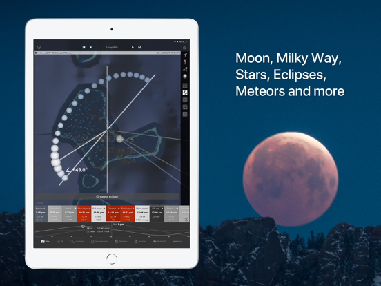
Night mode features a 3D representation of the Milky Way, pole stars and major constellations directly over the map, so you can easily visualize exactly how to align your shot.
Research and save your own list of favorite photographic locations, using 7 different map types (including 2 offline maps) and save them in your locations list. Favorite locations are always displayed right on the map.
Advanced features including visual sun and moon search, automatic time zone and elevation detection, correction for atmospheric refraction and height above the horizon, ensuring that you have the best possible information for planning your shoot.
You can even determine when the sun or moon will rise from behind nearby hills and mountains.
Key features:
- Time/direction of sun, moon, and galactic center rise/set
- View azimuth and altitude of sun/moon and the galactic center for any time of day/night
- Milky Way, stars and asterisms visualization via 3D map overlay
- Moon phase and % illumination
- Civil, nautical and astronomical twilight
- 2 topographic maps
- 2 offline map types
- Movable map pins: drag and drop the pin exactly where you need it
- Map autorotation using the compass (on compatible devices)
- Shadow lengths displayed to scale on map
- Save any location you want: no fixed lists
- Celestial events including moon phases, apogee, perigee, solstice, equinox
- Network connection not required for rise/set time, azimuths and sun/moon position
Advanced features:
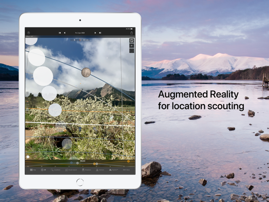
- Augmented reality view for on location scouting
- Saved location synchronization between devices and the free TPE web app
- Automatic time zone detection
- Elevation above sea level
- Distance, bearing and elevation angle between any two points
- Location import/export from KML
- Magnetic north option
- Configurable timeline display
- Sun/moon transit times
- 'Golden hour' time/duration
- Light pollution overlay
Geek features:
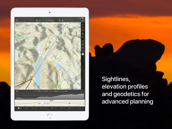
- Line of sight analysis
- Find when the sun/moon will appear from behind a hill or ridge
- Advanced visual sun and moon search
- Azimuth or altitude search priority
- New crescent moon visibility
- Distance to the visible horizon
Available map types include:
- Standard, Satellite/Hybrid, Terrain
- OpenCycleMap Topographic
- OpenStreetMap
Sunrise/sunset color forecasts are available (covering lower 48, southern Canada and Europe) with a subscription to the Skyfire service, available via in-app purchase.
Note:
- Maps and elevation-based calculations require a data connection, except for offline map tiles previously downloaded and stored on your device
- Topographic map data is available only between 60°N and 47°S
- Availability of map types is subject to change, due to 3rd party map service availability, terms or conditions
- The app itself supports only English language at present
- Augmented reality requires an iPhone 6s (or later), iPad Pro or 2017 model and iOS 11 or later
"One of the most useful apps for any nature photographer" - Outdoor Photographer Magazine
"It worked perfectly. The program was dead on…" - National Geographic
"One of the most powerful photography applications that I've seen, one that you'll be using for years and years." - AdoramaTV
The Photographer's Ephemeris (TPE) helps plan outdoor photography shoots in natural light, particularly landscape and urban scenes. It's a map-centric Sun, Moon and Milky Way calculator: see how the light will fall on the land, day or night, for any location on earth.
Whether you need at-a-glance information on today's sun, moon and Milky Way data for your current location, or need to plan a precise alignment of the full moon for a future shoot, TPE has the tools you need. The combination of augmented reality, line-of-sight analysis and visual search supports the most sophisticated photo planning needs.
Night mode features a 3D representation of the Milky Way, pole stars and major constellations directly over the map, so you can easily visualize exactly how to align your shot.
Research and save your own list of favorite photographic locations, using 7 different map types (including 2 offline maps) and save them in your locations list. Favorite locations are always displayed right on the map.
Advanced features including visual sun and moon search, automatic time zone and elevation detection, correction for atmospheric refraction and height above the horizon, ensuring that you have the best possible information for planning your shoot.
You can even determine when the sun or moon will rise from behind nearby hills and mountains.
Key features:
- Time/direction of sun, moon, and galactic center rise/set
- View azimuth and altitude of sun/moon and the galactic center for any time of day/night
- Milky Way, stars and asterisms visualization via 3D map overlay
- Moon phase and % illumination
- Civil, nautical and astronomical twilight
- 2 topographic maps
- 2 offline map types
- Movable map pins: drag and drop the pin exactly where you need it
- Map autorotation using the compass (on compatible devices)
- Shadow lengths displayed to scale on map
- Save any location you want: no fixed lists
- Celestial events including moon phases, apogee, perigee, solstice, equinox
- Network connection not required for rise/set time, azimuths and sun/moon position
Advanced features:
- Augmented reality view for on location scouting
- Saved location synchronization between devices and the free TPE web app
- Automatic time zone detection
- Elevation above sea level
- Distance, bearing and elevation angle between any two points
- Location import/export from KML
- Magnetic north option
- Configurable timeline display
- Sun/moon transit times
- 'Golden hour' time/duration
- Light pollution overlay
Geek features:
- Line of sight analysis
- Find when the sun/moon will appear from behind a hill or ridge
- Advanced visual sun and moon search
- Azimuth or altitude search priority
- New crescent moon visibility
- Distance to the visible horizon
Available map types include:
- Standard, Satellite/Hybrid, Terrain
- OpenCycleMap Topographic
- OpenStreetMap
Sunrise/sunset color forecasts are available (covering lower 48, southern Canada and Europe) with a subscription to the Skyfire service, available via in-app purchase.
Note:
- Maps and elevation-based calculations require a data connection, except for offline map tiles previously downloaded and stored on your device
- Topographic map data is available only between 60°N and 47°S
- Availability of map types is subject to change, due to 3rd party map service availability, terms or conditions
- The app itself supports only English language at present
- Augmented reality requires an iPhone 6s (or later), iPad Pro or 2017 model and iOS 11 or later
 このアプリはiPhone、iPadの両方に対応しています。
カテゴリー
写真/ビデオ
写真/ビデオ
リリース
2010/4/17
2010/4/17
更新
2020/2/6
2020/2/6
バージョン
4.9.1
4.9.1
言語
英語
英語
サイズ
58 MB
58 MB
条件
iPhone、iPod touch および iPad 互換 iOS 5.1 以降が必要 iPhone 5 用に最適化済み
iPhone、iPod touch および iPad 互換 iOS 5.1 以降が必要 iPhone 5 用に最適化済み
このバージョンの新機能
4.9.1
- New: search web service is included in the services status page
- Bug fixes
4.9
- New: support for what3words
- New: updated Locations page
- Updated: the World Magnetic Model has been updated to 2020-2025
- Improved: even better coordinate parsi
4.9.1
- New: search web service is included in the services status page
- Bug fixes
4.9
- New: support for what3words
- New: updated Locations page
- Updated: the World Magnetic Model has been updated to 2020-2025
- Improved: even better coordinate parsi
スクリーンショット - iPhone | iPad
スクリーンショット - iPhone | iPad
Crookneck Consulting LLC の他のアプリ » もっと見る
» 目的別iPhoneアプリ検索
- 辞書 » 日本語対応の辞書 » 英和辞典
- 学習 » 英単語 » 英会話 » クイズで楽しく
- スケジュール » 管理 » Googleカレンダー


遠近感のある文字で写真を飾る!写真加工アプリPERSTEXT..
Canon Marketing Japan Inc.無料
Instagram
Instagram, Inc.無料
B612 - いつもの毎日をもっと楽しく
SNOW Corporation無料
YouTube - 公式アプリで動画と音楽
Google LLC無料
MixChannel
Donuts Co. Ltd.無料
LINE Camera - 写真編集、アニメーションスタンプ..
LINE Corporation無料
Aviaryのフォトエディタ
Aviary無料
Fotor画像編集加工•写真効果•補正•コラージュアプリ
Chengdu Everimaging Science an..無料
カメラ360 - あなただけのカメラアプリ!100以上のファ..
PinGuo Inc.無料
InstaMag - Photo Collage Maker
Fotoable, Inc.無料


CatchApp新着アプリレビュー
 日本縦断てつどうの旅」")
様々な楽しみ方で運転士として成長していく鉄道運転士育成RPG「プラチナ・トレイン(プラトレ) 日本縦断てつどうの旅」
2016-05-17 00:00

日本語にはない英語発音のリスニングを楽しく学べる「発音どっち?英語リスニング 」
2014-12-20 12:00

指先の瞬発力が試されるカジュアルゲーム「早撃ちパニック」をリリース!
2014-12-08 15:21
新着アプリ動画
-
 ¥1500
¥1500
-
 ¥600
¥600
-
 ¥3000
¥3000