


このアプリのYoutube動画がある場合はURLを送信してください。詳細 »
APPLICATION INFO - iPhoneアプリの詳細情報
Summary:
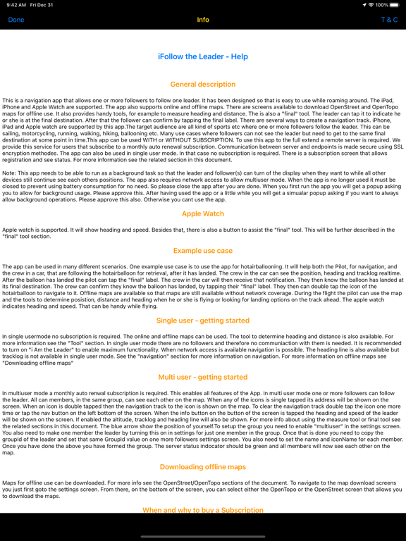
This is a navigation app to be used by single or multiple users. Online and offline downloaded maps can be used. Tools are provided to easily navigate to the leader or any other place. Distances and heading can be measured using build in tools. The leader can inform its followers that he or she is at the final destination. These are just a few highlights. For more detailed information please see the in app help information. To be able to use the app to the full extend a monthly auto renew subscription is required.
The target audience are all kind of sports etc where one or more followers follow the leader. This can be sailing, motorcycling, running, walking, hiking, ballooning etc. Many use cases where followers can not see the leader but need to get to the same final destination at some point in time.
This app can be used WITH or WITHOUT SUBSCRIPTION. To use this app to the full extend a remote server is required. We provide this service for users that subscribe to a monthly auto renewal subscription. Communication between server and endpoints is made secure using SSL encryption methodes. The app can also be used in single user mode. In that case no subscription is required. There is a subscription screen that allows registration and see status. For more information see the related section in this document.
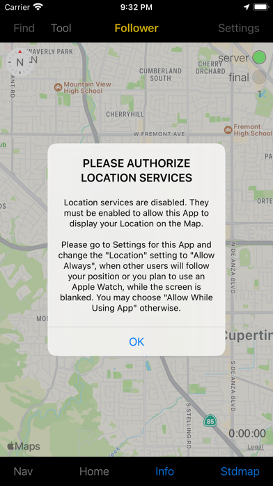
Note: This app needs to be able to run as a background task so that the leader and follower(s) can turn of the display when they want to while all other devices still continue see each others positions. The app also requires network access to allow multiuser mode. When the app is no longer used it must be closed to prevent using battery consumption for no need. So please close the app after you are done. When you first run the app you will get a popup asking you to allow for background usage. Please approve this. After having used the app or a little while you will get a simualar popup asking if you want to always allow background operations. Please approve this also. Otherwise you cant use the app.
Apple watch is supported. It will show heading and speed. Besides that, there is also a button to assist the "final" tool. This will be further described in the "final" tool section.
The app can be used in many different scenarios. One example use case is to use the app for hotairballooning. It will help both the Pilot, for navigation, and the crew in a car, that are following the hotairballoon for retrieval, after it has landed. The crew in the car can see the position, heading and tracklog realtime. After the balloon has landed the pilot can tap the "final" label. The crew in the car will then receive that notification. They then know the balloon has landed at its final destination. The crew can confirm they know the balloon has landed, by tapping their "final" label. They then can double tap the icon of the hotairballoon to navigate to it. Offline maps are available so that maps are still available without network coverage. During the flight the pilot can use the map and the tools to determine posistion, distance and heading when he or she is flying or looking for landing options on the track ahead. The apple watch indicates heading and speed. That can be handy while flying.
In single usermode no subscription is required. The online and offline maps can be used. The tool to determine heading and distance is also available. For more information see the "Tool" section. In single user mode there are no followers and therefore no communiaction with them is needed. When network access is available navigation is possible. The heading line is also available but tracklog is not available in single user mode. See the "navigation" section for more information on navigation. For more information on offline maps see "Downloading offline maps".
The app has a build in reference manual that can be shown by tapping the "info" button in the settings screen.
This is a navigation app to be used by single or multiple users. Online and offline downloaded maps can be used. Tools are provided to easily navigate to the leader or any other place. Distances and heading can be measured using build in tools. The leader can inform its followers that he or she is at the final destination. These are just a few highlights. For more detailed information please see the in app help information. To be able to use the app to the full extend a monthly auto renew subscription is required.
The target audience are all kind of sports etc where one or more followers follow the leader. This can be sailing, motorcycling, running, walking, hiking, ballooning etc. Many use cases where followers can not see the leader but need to get to the same final destination at some point in time.
This app can be used WITH or WITHOUT SUBSCRIPTION. To use this app to the full extend a remote server is required. We provide this service for users that subscribe to a monthly auto renewal subscription. Communication between server and endpoints is made secure using SSL encryption methodes. The app can also be used in single user mode. In that case no subscription is required. There is a subscription screen that allows registration and see status. For more information see the related section in this document.
Note: This app needs to be able to run as a background task so that the leader and follower(s) can turn of the display when they want to while all other devices still continue see each others positions. The app also requires network access to allow multiuser mode. When the app is no longer used it must be closed to prevent using battery consumption for no need. So please close the app after you are done. When you first run the app you will get a popup asking you to allow for background usage. Please approve this. After having used the app or a little while you will get a simualar popup asking if you want to always allow background operations. Please approve this also. Otherwise you cant use the app.
Apple watch is supported. It will show heading and speed. Besides that, there is also a button to assist the "final" tool. This will be further described in the "final" tool section.
The app can be used in many different scenarios. One example use case is to use the app for hotairballooning. It will help both the Pilot, for navigation, and the crew in a car, that are following the hotairballoon for retrieval, after it has landed. The crew in the car can see the position, heading and tracklog realtime. After the balloon has landed the pilot can tap the "final" label. The crew in the car will then receive that notification. They then know the balloon has landed at its final destination. The crew can confirm they know the balloon has landed, by tapping their "final" label. They then can double tap the icon of the hotairballoon to navigate to it. Offline maps are available so that maps are still available without network coverage. During the flight the pilot can use the map and the tools to determine posistion, distance and heading when he or she is flying or looking for landing options on the track ahead. The apple watch indicates heading and speed. That can be handy while flying.
In single usermode no subscription is required. The online and offline maps can be used. The tool to determine heading and distance is also available. For more information see the "Tool" section. In single user mode there are no followers and therefore no communiaction with them is needed. When network access is available navigation is possible. The heading line is also available but tracklog is not available in single user mode. See the "navigation" section for more information on navigation. For more information on offline maps see "Downloading offline maps".
The app has a build in reference manual that can be shown by tapping the "info" button in the settings screen.
 このアプリはiPhone、iPadの両方に対応しています。
カテゴリー
ナビゲーション
ナビゲーション
リリース
2020/12/22
2020/12/22
更新
2024/4/13
2024/4/13
バージョン
8.1
8.1
言語
サイズ
3.2 MB
3.2 MB
条件
このバージョンの新機能
No functional changes, app internal privacy updates
No functional changes, app internal privacy updates
スクリーンショット - iPhone | iPad
スクリーンショット - iPhone | iPad
Henri van Bommel の他のアプリ » もっと見る
» 目的別iPhoneアプリ検索
- 辞書 » 日本語対応の辞書 » 英和辞典
- 学習 » 英単語 » 英会話 » クイズで楽しく
- スケジュール » 管理 » Googleカレンダー


Yahoo!乗換案内
Yahoo Japan Corp.無料
Google マップ - ナビ、乗換案内
Google LLC無料
Yahoo!カーナビ
Yahoo Japan Corp.無料
乗換NAVITIME(乗換ナビタイム) - 運行情報や路線図..
NAVITIME JAPAN CO.,LTD.無料
Yahoo! MAP-ヤフーマップ
Yahoo Japan Corp.無料
乗換案内
Jorudan Co.,Ltd.無料
賃貸物件検索 SUUMO(スーモ)でお部屋探し
Recruit Co.,Ltd.無料
NAVITIME(乗換と地図の総合ナビ)
NAVITIME JAPAN CO.,LTD.無料
NAVITIMEドライブサポーター - カーナビ&渋滞情報&..
NAVITIME JAPAN CO.,LTD.無料
お部屋探しはライフルホームズ賃貸・マンション・不動産物件検索
LIFULL Co., Ltd無料


CatchApp新着アプリレビュー
 日本縦断てつどうの旅」")
様々な楽しみ方で運転士として成長していく鉄道運転士育成RPG「プラチナ・トレイン(プラトレ) 日本縦断てつどうの旅」
2016-05-17 00:00

日本語にはない英語発音のリスニングを楽しく学べる「発音どっち?英語リスニング 」
2014-12-20 12:00

指先の瞬発力が試されるカジュアルゲーム「早撃ちパニック」をリリース!
2014-12-08 15:21
新着アプリ動画
-
 ¥1500
¥1500
-
 ¥600
¥600
-
 ¥3000
¥3000