


このアプリのYoutube動画がある場合はURLを送信してください。詳細 »
APPLICATION INFO - iPhoneアプリの詳細情報
GPS Map Camera Geotag Photo is a powerful and versatile app designed to enhance your photography experience by adding geotags and location information to your photos. This app is particularly useful for travelers, outdoor enthusiasts, and anyone who wants to document their journeys and experiences with precision. Geotag is an amazing way to add all the current place details in a photo to keep memories of where you are in the photos.
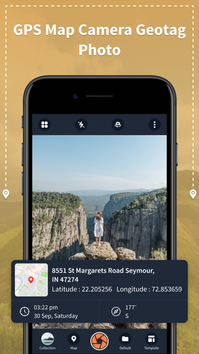
This GPS Map Camera Geotag Photo app utilizes GPS data to automatically add location information to your photos. This makes it easy to track where each photo was taken, creating a visual record of your adventures. The GPS Map Camera Geotag Photo is seamlessly integrated with your device's camera, allowing you to take photos directly from within the app. This ensures that every picture you capture is automatically tagged with current location information.
The GPS Map Camera Geotag Photo App allows you to view a map within the app that displays the locations of all your geotagged photos. This feature is perfect for creating a visual journey log or for planning future trips based on your previous experiences. With a GPS Map Camera, you can easily share your geotagged photos on social media, allowing friends and followers to explore your adventures with you. With the GPS Map Camera, you can customize your choice of templates in your way. Save all the photos in the collection folder.
FEATURES:
The best way to add geotag and location details in your photos
It is simple and easy to keep all photos in collection folders
GPS Map Camera to keep your place memories in photos
Front and back, both cameras are supported
Flash supported
Option to Add grid-style style to photos
Have the choice to set a timer, autofocus, mirror effects, and capture sounds according to your needs
Simple app coming with clear UI Design
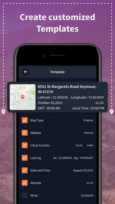
Customized Tag Templates:
When utilizing this incredible tool, you may modify the tag details as per your need
You can modify the collections by adding or removing tags
Include tags from the various collections, including address, latitude/longitude, plus code, date and time, time zone, numbering, logo, note/hashtag, wind, humidity, pressure, altitude, accuracy, and a host of other information
Alter the geotag details font style
Select a different stamp size
This GPS Map Camera Geotag Photo app utilizes GPS data to automatically add location information to your photos. This makes it easy to track where each photo was taken, creating a visual record of your adventures. The GPS Map Camera Geotag Photo is seamlessly integrated with your device's camera, allowing you to take photos directly from within the app. This ensures that every picture you capture is automatically tagged with current location information.
The GPS Map Camera Geotag Photo App allows you to view a map within the app that displays the locations of all your geotagged photos. This feature is perfect for creating a visual journey log or for planning future trips based on your previous experiences. With a GPS Map Camera, you can easily share your geotagged photos on social media, allowing friends and followers to explore your adventures with you. With the GPS Map Camera, you can customize your choice of templates in your way. Save all the photos in the collection folder.
FEATURES:
The best way to add geotag and location details in your photos
It is simple and easy to keep all photos in collection folders
GPS Map Camera to keep your place memories in photos
Front and back, both cameras are supported
Flash supported
Option to Add grid-style style to photos
Have the choice to set a timer, autofocus, mirror effects, and capture sounds according to your needs
Simple app coming with clear UI Design
Customized Tag Templates:
When utilizing this incredible tool, you may modify the tag details as per your need
You can modify the collections by adding or removing tags
Include tags from the various collections, including address, latitude/longitude, plus code, date and time, time zone, numbering, logo, note/hashtag, wind, humidity, pressure, altitude, accuracy, and a host of other information
Alter the geotag details font style
Select a different stamp size
カテゴリー
ナビゲーション
ナビゲーション
リリース
2023/11/7
2023/11/7
バージョン
1.0
1.0
言語
サイズ
42.5 MB
42.5 MB
条件
スクリーンショット
Kajalben Savaliya の他のアプリ » もっと見る
» 目的別iPhoneアプリ検索
- 辞書 » 日本語対応の辞書 » 英和辞典
- 学習 » 英単語 » 英会話 » クイズで楽しく
- スケジュール » 管理 » Googleカレンダー


Yahoo!乗換案内
Yahoo Japan Corp.無料
Google マップ - ナビ、乗換案内
Google LLC無料
Yahoo!カーナビ
Yahoo Japan Corp.無料
乗換NAVITIME(乗換ナビタイム) - 運行情報や路線図..
NAVITIME JAPAN CO.,LTD.無料
Yahoo! MAP-ヤフーマップ
Yahoo Japan Corp.無料
乗換案内
Jorudan Co.,Ltd.無料
賃貸物件検索 SUUMO(スーモ)でお部屋探し
Recruit Co.,Ltd.無料
NAVITIME(乗換と地図の総合ナビ)
NAVITIME JAPAN CO.,LTD.無料
NAVITIMEドライブサポーター - カーナビ&渋滞情報&..
NAVITIME JAPAN CO.,LTD.無料
お部屋探しはライフルホームズ賃貸・マンション・不動産物件検索
LIFULL Co., Ltd無料


CatchApp新着アプリレビュー
 日本縦断てつどうの旅」")
様々な楽しみ方で運転士として成長していく鉄道運転士育成RPG「プラチナ・トレイン(プラトレ) 日本縦断てつどうの旅」
2016-05-17 00:00

日本語にはない英語発音のリスニングを楽しく学べる「発音どっち?英語リスニング 」
2014-12-20 12:00

指先の瞬発力が試されるカジュアルゲーム「早撃ちパニック」をリリース!
2014-12-08 15:21
新着アプリ動画
-
 ¥1500
¥1500
-
 ¥600
¥600
-
 ¥3000
¥3000